Good Earth CSA Home Page
This Week's Share!
Vegetable Identifier
Recipes
Good Earth Newsletter
About Good Earth CSA
Printable Sign-Up Form
What is Community Supported Agriculture?
How does a CSA work?
What is a "Share?"
Typical Share Contents
Links

|
Directions to the Farm
From Cambridge/Central
Square:
-
Take the Mass Pike (Rt.
90) West.
-
Take Exit 12 (a Framingham
exit) onto Rt. 9 West.
-
Go about 8 miles on Rt.
9 to the intersection of Rt. 9 and Rt. 135.
-
Turn onto Rt. 135 East
(it actually heads South at this point).
-
Continue on Rt. 135 through
Westboro Center (crossing Rt. 30 at the rotary).
-
The Farm is 1.1 miles
past the rotary on the left. You'll pass Harvey's farmstand on the left.
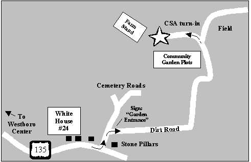
Stay to the left when the road forks (keeping you on Rt. 135) and turn
in at the cemetery entrance, which is marked by two stone pillars. Follow
the farm map, driving slowly, and being very respectful of anyone visiting
the cemetery.
From Jamaica Plain:
-
Take your favorite shortcut
to Rt. 9 West.
-
You can either:
- Take Rt. 9 all the
way to Rt. 135 East and then follow directions from #4 above, or
- Take Rt. 9 to Rt.
128 (Rt. 95) North. Exit onto the Pike (Rt. 90) West and then follow directions
from #2 on.
Local Directions:
The farm is located
behind St. Luke's cemetery near Westboro Center (the intersection of Rt.
135 and Rt. 30). It's 1.1 miles east of Westboro Center on Rt. 135. Follow
directions from #6 above.
Farm Map
|